
![]()
PROFESSEURS :
Sandra FOCARDI : giotto.ulivi@dada.it
ELEVES :
![]()
![]()
PLAN ![]()
CHEMICAL AND BIOLOGICAL MONITORAGGIO" OF STREAMS
A.S. 1999-2000
HIGH SCHOOL: GIOTTO ULIVI - BORGO SAN LORENZO- FIRENZE
INTRODUCTION
The job has
been carried out by the classes 2° B and 3° B of the section of experimental
sciences of the Giotto Ulivi high school, in the months of April-May of
the year 2000.
Purpose of the present job is acquiring chemical- physical-biological
data of the streams to elaborate a quality map of the waters in the territory
of the Mugello. Main objective of the job is involving the students in
a first hand experience job, training them in laboratory practice aimed
to an environmental study and in the following elaboration of data and
layout of a final report.
![]()
JOB PLAN
1. Territory
1.a Introduction
1.b Choice of the stream and geographical location2 Biomonitoring
2.a Introduction
2.b E:B:I: method
2.c Macroinvertebrates3 Chemical-physical parametres
5 Results
![]()
Introduction
The present
physical and morphological conformation of the Mugello Valley is the result
of the geological and tectonics evolution of the Appennini range and has
been affected by climatic variations (glacial and interglacials periods
of the Quaternary era). Such changes have affected the erosive agents
and their intensity.
Also human presence has contribued and contributes to the evolution of
the environmental features. Man appeared in the Mugello Valley in the
middle Palaeolithic period with groups of nomadic hunters. The weight
of his presence on the territory, has been felt when stable installations
were created , with basically agricoltural economy (installation dating
to the age of Copper and Bronze). From that moment on the practices of
exploitation of the territory have modified it substantially up to the
present order.
In the territory of the Mugello three different geomorphological units
are recognizable.
The differences are due to morphogenetical
processes, morphological dynamics (intensity and speed with which the
morphological variations in the territory take place) and shapes:
1-RELIEFS
2-THE OLD LACUSTRINE BASIN
3-INTERMONTANE VALLEYS
1- They occupy
a large part of the territory; they coincide with the southern dorsal-
Montegiovi, Montesenario, Calvana- and the Appennini watershed to North
between Citerna Mountain and Falterona. The shaping of the landscape is
due to the progressive incision of the streams that come down and that
confer uneven morphology with high pitched crests and steep slopes alternate
to narrows and deep valleys.
2- It coincides with Mugello valley
: the upper- middle part of the present basin of the Sieve up to Contea.
It is a complex unit, with alternate hilly reliefs, valley flats and old
terraced areas. The shaping of this zone is due to the chartered waters
and to the slope processes: landslides of glide and superficial erosion
with relatively slow morphological dynamics.
Areas with hilly morphology in the
Appennini range - valley of Firenzuola- with argillaceous prevalence characterized
by intense phenomena of disarrangement. In fact they are notably degraded
areas with slopped stability problems and frequent landslides ( collapse
and glide). Considering the biological(vegetation and fauna) and anthropic
(use of the ground) components, we could decompose the three geomorphological
units into landscape unit, each characterized from homogeneous habitat
for determined physical-biological features.
Our researh
has been addressed toward the Faltona stream, right tributary of Sieve
river. The course of water derives from the artificial pond Piantamalanni
(536 m s.l.m.) and elapses for the almost totality of his journey, parallel
to 302 Brisighellese -Ravennate state street and reaches the Sieve at
Canicce farm.(196 m s.l.m.). In its way it crosses the inhabitated areas
of Polcanto, Poggiolo and Faltona. The two thirds of the river bed present
arather uneven morphology, in a narrow valley with slopes covered by mixed
woods of oaks such as black alder , haphornbeam and willows.
In the choice of the sites the following points have been taken in consideration
a-presence of infrastructuresand inhabitated nucleuses;
b-morphology of the sream: width of the river bed, maximum depth, uneveness
of the bottom;
c-distance of the point of survey from the source;
d- type of riparian vegetation;
![]()
Introduction
Biomonitoring
consists of the use of species or groups of species of plants or animals
to evaluate the impact of huaman activities on the environment. It is
based on a simple concept: a toxic substance is harmfull to living organisms
as a definition; The methodology is therefore based on the presence and
distribution of the living beings in a specific environment. An effective
biomonitoring methodology must be able to clearly identify the effects
of human activities, to separate it from those of the environmental nature
effects such as the distribution of the species of living organisms in
relationship to the characteristic physical variations of the environment
(altitude, ground, climate etc.). A bioindicator doesn't generally supply
indications on the kind of polluting substance nor the cause of pollution,
but nevertheless it presents the following advantages:
1- It provides informations not tied up to particular moments, being constantly
in the environment; it suffers from the effect of the polluting factors
and we are allowed to evaluate even when its cause is no more present.
2- It makes possible the evaluation of synergical effects due to the presents
of more than a single polluting substance.
3- It helps to find the presence of toxic substances even in very small
concentration; the effects could be direct or due to bioaccumulation phenomena
in the food
4- chain.
5- It provides biological effective answers, thus resulting indicator
of the environmental quality.
Not all the
organisms can be use as bioindicators; typical qualities of a living organism
used as a bioindicator are as follows:
1- tested sensitivity to harmfull substances;
2- wide and uniform spreading in the environment;
3- scarce mobility;
4- poliannual biological cycle;
5- knowledge of the territorial distribution of the organisms and of its
relationship with life environment;
6- bioaccumulation capacity
The E.B.I. methodology (Extented Biotic Index) is the most used one in Italy and it is based on the sensitivity to pollutants shown by some faunistic groups and on the biological variability inside the macroinvertebrates comunity. We must evaluate the presence of bentonic organisms, i.e. organisms living at the bottom of streams. Methodology is based on the attribution of numerical conventional indexes determining a score ( sistematic units amount) through which the water quality can be classified. The E.B.I. index can be calculated according to the following chart:
| Numero totale delle U.S. costituenti la communità (seconde ingresso) |
| Gruppi
faunistici che determinano con la loro presenza l'ingresso orizzontale in tabella (primo ingresso) |
0-1 | 2-5 | 6-10 | 11-15 | 16-20 | 21-25 | 26-30 | 31-35 | 36... | |
| Plecotteri | Più di una sola U.S. | - | - | 8 | 9 | 10 | 11 | 12 | 13 | 14 |
|
Una sola U.S. |
- | - | 7 | 8 | 9 | 10 | 11 | 12 | 13 | |
| Efemerotteri (tranne fam. Baetidae, Caenidae) | Più di una sola U.S. | - | - | 7 | 8 | 9 | 10 | 11 | 12 | - |
| Una sola U.S. | - | - | 6 | 7 | 8 | 9 | 10 | 11 | - | |
| Tricotteri (ed inoltre fam. Baetidae, Caenidae) | Più di una sola U.S. | - | 5 | 6 | 7 | 8 | 9 | 10 | 11 | - |
| Una sola U.S. | - | 4 | 5 | 6 | 7 | 8 | 9 | 10 | - | |
| Gammaridi | Tutte le U.S. sopra assenti | - | 4 | 5 | 6 | 7 | 8 | 9 | 10 | - |
| Asellidi | Tutte le U.S. sopra assenti | - | 3 | 4 | 5 | 6 | 7 | 8 | 9 | - |
| Oligocheti o Chiro no midi | Tutte le U.S. sopra assenti | 1 | 2 | 3 | 4 | 5 | - | - | - | - |
| Tutti i taxa precedenti assenti | Possono esserci organismi a respirazione aerea | 0 | 1 | - | - | - | - | - | - | - |
| Classi di qualita | Volori E.B.I. | Giudizio | Colore di riferimento |
| I | 10-11-12... | Ambiente non inquinato o non alterato in modo sensibile | Azzurro |
| II | 8-9 | Ambiente in cui sono evidenti alcuni effetti dell'inquinamento | Verde |
| II | 6-7 | Ambiente inquinato | Giallo |
| IV | 4-5 | Ambiente molto inquinato | Arancione |
| V | 1-2-3 | Ambiente forte mente inquinato | Rosso |
Example: in our analysis 10 Systematic Unities have been sampled two of wich belonging to Plecoptera, the most sensitive organisms to pollution. Plecoptera represent the chart entry line (the first in our case); such entrance is of qualitative type while the second (represented with a column) is of quantitative type and takes into account the amount of the Community Systematic Unities. The index value is drawn in the box created by the meeting of the two entrances. In the example the index value is 8 and corresponds to the class of II - Quality environment with moderate symptoms of pollution or alteration (green is the reference colour).
![]()
Belonging organisms
to different Phyla and observable to naked eye. They could be: Gasteropods,
Crustacea, Oligochaeta, Hirudinea, etc. but above all bugs. The latter
are represented by various orders: Plecoptera, Ephemeroptera, Odonata,
Diptera, Coleoptera, Tricoptera, etc.
The bugs that live the river bottoms, present morphological adaptations
that allow them not to be dragged by the water flow and so, (1) the early
stadiums of the Plecoptera or Ephemeroptera present a dorsoventrally flattened
body, (2) some dipteral larvas have systems such as suckers, thorns etc.
for the anchorage to the substratum, (3) some Tricoptera are provided
with involucra to contain larvas so making them heavier.
PHYSICAL PARAMETERS
FLOW RATE
Water volume that crosses a perpendicular section of the stream direction
in a specific point of the river bed using m3/s as unit.
CURRENT SPEED
It depends on the riverbed slope and depth. It identifies the stream capacity
of transport. Solid materials of the riverbed present a hangover speed
limit (Wa), if the current speed exceeds the speed limit, the material
is transported by the river. We have top speed in yhe center of the riverbed.
Speed influences even:
1. the quantity
of dissolved oxygen;
2. temperature;
3. turbidity;
4. nutrients circulation.
5.
OUTFLOW COEFFICIENT
Ratio between the volume of drained off water and volume of the water
fallen in a year. Relieves are made at the river mouth and it is always
lower than 1.
REGIMEN
Determined by the increment of the river outflow rate in a year.
TEMPERATURE
Presents vertical and horizontal variations. In the fast and shallow rivers
it doesn't present significative increment of lapse rate. In the big rivers
it presents a vertical lapse rate. Surface temperature is affected by
the outside weater conditions.
CHEMICAL PARAMETERS
ACIDITY -
pH
The natural waters present a pH range 6 - 8.5. Such conditions are favourable
to the life of most of the living organism. Variations in pH indicate
presence of strong acids/weak bases salts or presence of weak acids/strong
bases salts (acid and alcaline hydrolysis).
HARDNESS
It expresses the water power to make soaps precipitate total hardness
is the concentration of calcium and magnesium salts present in the water.
It is expressed either in CaCO3 mg/l or "French Degrees" (1° = 10 mg/l
CaCO3).
NITRATES,
NITRITES and NH4+
Such anions originate mainly from the agricoltural activity and the mineralization
of organic nitrogen.
OXYGEN
Important element for the living community and one of basic importance
in the determination of the faunistic component. There is plenty of it
in running and cold waters. The amount of dissolved oxygen indicates the
pollution level in a watercourse.
The pollution level in a waterause. The pullution level comes to be determined
by 2 parameters: B.O.D. and C.O.D. B.O.D. (Biological Oxygen Demand):
it determines the biological demand of oxygen of the defradator heterotroph
microorganisms playing an important past in the degradation of organic
substances.
C.O.D. (Chemical Oxygen Demand): it determines the consumed oxygen amount
in the chemical oxidation of organic sustances difficult to be degraded
CHLORIDES
Anions of geologiical origin present in any natural water whose mineralogical
equilibrium is assured by their presence. A high concetration (>30 mg/l)
of chlorides may originate problems concerning water flora survival and
development.
PHOSPHATES
The mayority of such anions derives either from wat4er percolation in
exceedingly fertilized agricoltural grounds or from domestic or industrial
waters disposal. High concentration levels may originate eutrophication
phenomena.
![]()
Materials used for surveys in the countryside
- macroinvertebrate
nets;
- collecting bowls;
- entomological tweezers;
- magnifier;
- corked PE bottles for sample transfer to laboratory;
- thermometer;
- pH - meter;
- chronometer;
- survey charts;
- systematic keys;
- metric wheel;
- graduated pole;
- gloves;
- boots.
Materials for the examination in laboratory
- optical microscope;
- Petri plates;
- AQUAKIT.
SURVEY CHART
SETTING
We have predisposed a simplified chart wich takes into consideration the
most important bioindicator, even considering the plan didactic importance.
Students have been provided with siplified analytical keys and recognition
cards of Systematic Units. Students have been divided into groups of 5
- 6 people. Any single river area has been sampled by four groups and
the results compared to those elaborated by the teacher (see refernce
column).
MACROINVERTEBRATES
CAPTURE
The process has been carried out through the use of nets scraping off
the bottom upstream, deplacing the stones on the bottom by hands or feet
to make capture easier. Sometimes Students have washed stones with the
water close to net mouth. The content of the net has been poured in the
collecting bowls for the first identification taking out part of the material
for a further observation using an optical microscope.
![]()
Date : 27 April
2000
Time : 10:00 a.m.
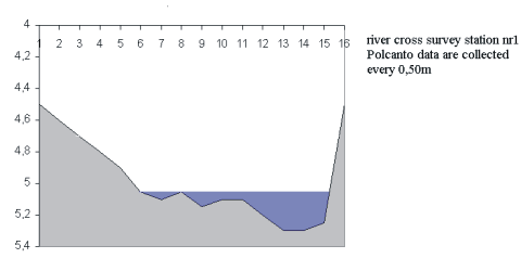
Survey station n.1 : Polcanto (404 m s.l.m.) - NW
Position : right bank
Air temperature : 16.5 °C
Water appearance : clear
Speed : 0,34 m/s
Volume : 1,96m3
Flowrate : 0,17 m3/s
Date : 05 May
2000
Time : 11:30 a.m.
Survey station n.2 : Le Canicce (196 m s.l.m.) - N
Position : right bank
Air temperature : 19.8 °C
Water appearance : clear
Speed : 5,5 m/s
Volume : 5,11m3
Flowrate : 0,4 m3/s

CHEMICAL-PHYSICAL ANALYSIS (AQUAKIT)
|
Station n.1 |
Station n.2 Loc. Canicce |
|
| Temperature | 11.2°C | 13.9°C |
| PH | 8.0 | 7.8 |
| Nitrates | 5.0 mg/l | 12.0 mg/l |
| Nitrites | 1.7 mg/l | 0.8 mg/l |
| NH4+ | 0.4 mg/l | 0.5 mg/l |
| Chlorides | 18.0 mg/l | 21.0 mg/l |
| Phosphates | 0.4 mg/l | 0.4 mg/l |
| Oxygen | 7.9 mg/l | 7.9 mg/l |
| Hardness | 23 °fr. | 27 °fr. |
E.B.I. Index Survey Station n.1 -Polcanto
|
Systematic Units
|
Gr.1 | Gr. 2 | Gr. 3 | Gr. 4 | average values | Ref. |
|
Plecotteri
|
2 | 1 | 1 | 1 | 1.25 | 2 |
|
Efemerotteri
|
4 | 3 | 6 | 3 | 4.00 | 6 |
|
Tricotteri
|
4 | 3 | 2 | 4 | 3.25 | 5 |
|
Irudinei
|
1 | 0 | 0 | 0 | 0.25 | 1 |
|
Coleotteri
|
1 | 0 | 1 | 1 | 0.75 | 1 |
|
Eterotteri
|
1 | 1 | 0 | 1 | 0.75 | 3 |
|
Odonati
|
0 | 1 | 0 | 0 | 0.25 | 1 |
|
Ditteri
|
2 | 0 | 0 | 1 | 0.75 | 3 |
|
Crostacei
|
1 | 2 | 1 | 1 | 1.25 | 2 |
|
Gasteropodi
|
0 | 0 | 0 | 0 | 0.00 | 1 |
|
Oligocheti
|
1 | 0 | 0 | 0 | 0.25 | 0 |
|
Surveys
|
Gr.1 | Gr. 2 | Gr. 3 | Gr. 4 | average values | Ref. |
|
S.U. Total amount
|
17 | 11 | 11 | 12 | 12 | 25 |
|
E.B.I. Index
|
10 | 8 | 8 | 8 | 8 | 11 |
E.B.I. Index Survey Station n.2 - Le Canicce
|
Systematic Units
|
Gr.1 | Gr. 2 | Gr. 3 | Gr. 4 | average values | Ref. |
|
Plecotteri
|
1 | 1 | 2 | 2 | 1.50 | 2 |
|
Efemerotteri
|
1 | 2 | 1 | 3 | 1.75 | 2 |
|
Tricotteri
|
1 | 1 | 2 | 0 | 1.00 | 2 |
|
Irudinei
|
0 | 1 | 1 | 0 | 0.50 | 0 |
|
Coleotteri
|
0 | 0 | 1 | 0 | 0.25 | 1 |
|
Eterotteri
|
1 | 2 | 0 | 1 | 1.00 | 2 |
|
Odonati
|
0 | 2 | 0 | 1 | 0.75 | 2 |
|
Ditteri
|
0 | 1 | 1 | 0 | 0.50 | 2 |
|
Crostacei
|
0 | 0 | 0 | 0 | 0.00 | 0 |
|
Gasteropodi
|
1 | 0 | 1 | 0 | 0.50 | 1 |
|
Oligocheti
|
2 | 1 | 1 | 1 | 1.25 | 2 |
|
Surveys
|
Gr.1 | Gr. 2 | Gr. 3 | Gr. 4 | average values | Ref. |
|
S.U. Total amount
|
7 | 11 | 10 | 8 | 9 | 16 |
|
E.B.I. Index
|
7 | 8 | 8 | 8 | 8 | 10 |
![]()
The E.B.I. index
value are about 1 point underrated as to reference values since students
not always have succeded recignizing not enough striking species. However
the values are compatible with the different environmental situations
of the watercourse , even taking into account the season when the experince
nas been carried out (limited demographic load in Polcanto and Faltona
survey station) The result show good quality waters even downstream form
the small urban conglomerates where nevertheless a dicrease in the E.B.I.
index is reported. From the close observation of the best waters are those
situated upstream from Polcanto survey station.
E.B.I. methodology seens to be suitable even to a didactic livel in exploratory
investigations about the enviromental situation of the waters of our rivers
because indexes have shown to be completely reliable. Our aim in making
the student aware about pollution has been fullfilled. Students' involvement
in a field investigation has been very active event if not at the same
lebel for each group (as shown in diagrams and results); nevertheless
they have been invoved in the job from planning data treatment.
![]()
![]()
![]()
![]()
![]()
![]()
![]() Université
de Liège
Université
de Liège